On the map on My data plate(actually its a sheet of paper)it shows the northern zones similar,but not the same. The one You posted is roof load tho and I think the one in My furnace closet shows more generalized "North" "Middle" and "Hurricane" zones. It mentions both wind and snow "live load".
It is marked Ansi A58.1 - 1972 although My home is a 1976. The lower left corner of the plate is missing,that lower left is one place the zone names should be so some deciphering is needed to determine the snow load ratings per zone.
This site mentions My map for wind;
http://www.gostructural.com/article.asp?id=1401
I haven't found a duplicate map image on the net,most of the PDFs and such are wind related and/or don't show the map,at least I haven't found one for free.
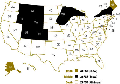
Looks to be that both nwwoman and I are close to the Middle zone on Your map,on My map it is called "North" and I'm in it(near MN)but not by much. On My map the eastern 1/3 of Washington State is in the North zone.
I'll guess it is the Pacific winds that keep most of Washington State classified as Southern.In that respect maybe My map is shaded a bit more acurately,I would think that farther inland the Canadian cold would drop down and influence the eastern end of Washinton,,just a guess tho.
As to North Dakota(not to mention SD)being in the South zone HUH?!?! Its gotta be colder than He** and snowy! Maybe they count on high wind to blow the snow off of roofs?!?! I'm mystified. ND isn't shown in the North zone on My map either,,kinda hinky I think,,I've never been there but do believe they get lots of snow.
Wait a minute,,could the mountains explain the western black-shaded Middle zone and lake effects explain the other 2 black ones? Do lake effects back up against prevailing winds to explain MN? LOL! I'm missing something or these maps We have raise more questions than answers. Ahhh well,its fun and educational.
Dean
After perusal of My post I deem it "sendworthy",by My messed-up standards that is!(hmm looks like a good signature for me)